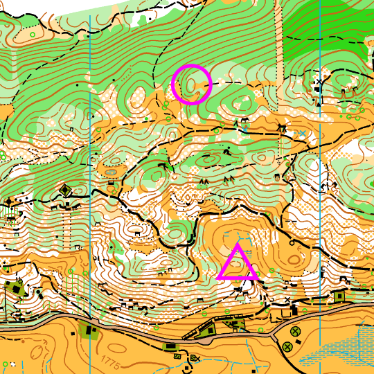
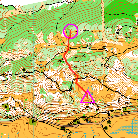
About best orienteering route choice web app
Best-orienteering-route-choice is a demo web application for analyzing forest orienteering route choices. The main feature of this app is the ability of automatically computing the fastest route from the map.
How we compute the fastest route
Our algorithm computes an approximation of the real fastest route on the terrain. The algorithm works as follows:
- We discretize the orienteering map with a grid, in which each cell is characterized by an ISOM symbol and an elevation. The denser the grid, more precise is the approximation but more time is required by the computation. In the demo app, cells are 10x10 meters squares.
- We assigned a default speed to each ISOM symbol, as shown in the table at the end of the page. These values are parameters of the algorithm and can be modified by the user (not in the current demo).
- We compute the travel time for going from a cell its neighbors taking into account two factors: (i) the runnability of both cells and (ii) the slope of the terrain, i.e., the difference in elevation of the cells. In particular, the travel time follows the "Tobler's hiking function", which is commonly used to determine the hiking speed taking into account the slope angle.
- We perfom an exhaustive search among all the possible paths to find the one with the minimum travel time.


Is the fastest route the same as the best route?
No, it isn't. Best route choice depends on a lot of factors other than terrain runnability, first of all the execution difficulty in terms of navigation. For élite orienteers, with exceptional navigation skills, the fastest route is often the best one. Anyhow, the knowledge of the fastest route is a valuable information for many aspects of an orienteering race.
Who can benefit from this app
- Orienteers can have a lot of fun using this app: it is interesting to think a route and verify if it is the "fastest route from the map". It can be a good mental training, too.
- Course setters can use it as an instrument to support the course plannig because it eases the evaluation of leg's choices, especially for long legs. Moreover, it can help to predict the race time.
- Race organizer can use it as an objective method to measure courses' length and climb.
- Orienteering coaches can tailor the symbol-speed table for each athlete and analyze their performance better.
Future plan
We'd like to develop this app in many directions and adding the following features: add more maps, let users upload maps, let users change the symbol-speed table, entire course analysis, GPS integration for tailoring speed table, and more.Developers
The project is run by Marco Della Vedova, computer scientist and (average) orienteer, and Lucia Curzio, geographer and (good) orienteer.
You can reach us at marco.dellavedova@gmail.com. If you want to get updated on the project, you can fill the google form.
Symbol-speed table
| Symbol | Description | Pace (min/km) |
| 109.0 | Erosion gully | 5 |
| 110.0 | Small erosion gully | 5 |
| 201.0 | Impassable cliff | 15 |
| 201.1 | Impassable cliff | 15 |
| 202.0 | Rock pillar | 9999 |
| 203.0 | Passable rock face | 10 |
| 203.1 | Passable rock face | 8 |
| 203.2 | Passable rock face | 8 |
| 210.0 | Stony ground | 8 |
| 212.0 | Bare rock | 7 |
| 301.0 | Lake | 9999 |
| 302.1 | Pond | 9999 |
| 306.0 | Crossamble small watercourse | 5 |
| 307.0 | Minor water channel | 5 |
| 308.0 | Narrow mash | 6 |
| 310.0 | Mash | 5 |
| 310.1 | Small mash | 5 |
| 311.0 | Indistinct mash | 5 |
| 401.0 | Open land | 3.5 |
| 401.1 | White for yellow | 4 |
| 402.0 | Open land with scattered trees | 4 |
| 403.0 | Rough open land | 4.5 |
| 404.0 | Rough open land with scattered trees | 4.5 |
| 406.0 | Forest: slow running | 5 |
| 407.0 | Undergrowth: slow running | 5 |
| 408.0 | Forest: difficult to run | 6 |
| 409.0 | Undergrowth: difficult to run | 6 |
| 410.0 | Vegetation: very difficult to run | 7.5 |
| 502.0 | Major road | 3 |
| 503.1 | Minor road under construction | 3.5 |
| 503.3 | Minor road | 3.5 |
| 504.0 | Road | 3.5 |
| 505.0 | Vehicle track | 3.5 |
| 506.0 | Footpath | 3.5 |
| 507.0 | Small footpath | 4 |
| 508.0 | Less distinct small path | 4.5 |
| 519.0 | Stone wall | 5 |
| 522.0 | Fence | 5 |
| 523.0 | Ruined fence | 5 |
| 524.0 | High fence | 15 |
| 526.0 | Building | 9999 |
| 526.1 | Small building | 9999 |
| 527.0 | Settlement | 9999 |
| 529.0 | Paved area | 3.5 |
| 529.1 | Bounding line | 4 |
| 529.9 | Stairway | 4.5 |
| 530.1 | Small ruin | 10 |
| 534.0 | Pipeline uncrossable | 9999 |
| 853.0 | Bounding line | 4 |